Montana’s Winter Storm
Dumping right now as I write this Winter Storm Blog Thursday morning in Cascade Montana.
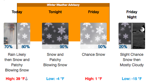
Weather Underground says…snow expected, possibly heavy at times. Total snow accumulations of 2-5 inches are expected, with 8-16 inches expected in the mountains.
 Bring it. We love all of the snow! Makes for a more comfortable summer here in central Montana. Maybe we can avoid the fires we witnessed this last year. Lots and lots of destruction. Historically our most devastating fire season. And it looked like our water situation int he spring was rosy.
We had complaints about the water being too high in the spring and early summer. Yes, that is the world we live in. And then…fire.
So again I caution you the reader to hold your breath for another 17 weeks. Then we will know how the state will fare this coming summer. The summer plays a role in the fire season equation.
We are fortunate to live here on the Missouri River with a 13K square mile drainage to draw from. Other resources are not that lucky. And we are looking strong right now. Will it hold up?
Only Mother Nature knows…
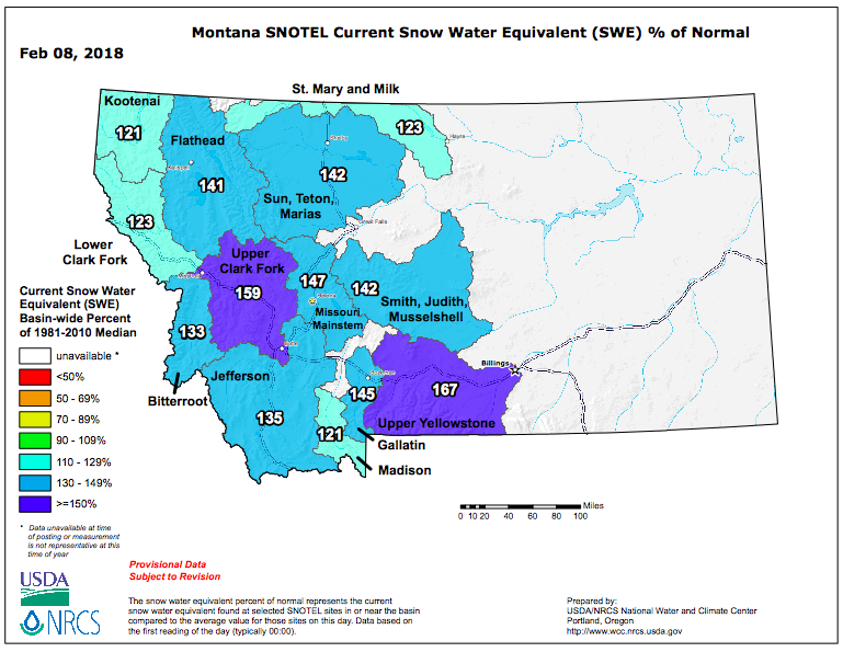
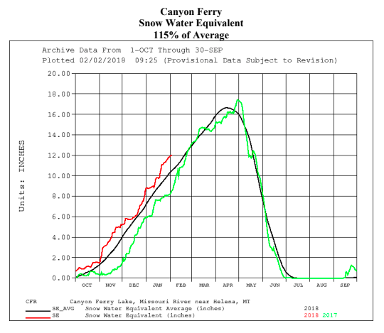
The model looks good for the remainder of winter. Check out the Montana Snow Water Equivalent map below and the chart below that. The chart is from DNRC and shows where we are at filling of the reservoir. We always get close to filling Canyon Ferry. Most years we get there. How the water managers handle the winter ahead is important. They follow models they have created to achieve the goal. The one thing the several factions controlling Missouri River water state is if we get a bunch of rain post April 15th it changes the equation. Those are the years we see flows beyond 12K, and up to 20K+. Which we have not seen since 2011.
When you hear and see other institutions talking about flushing flows, they are referring to 15K+ flows for a period of 3 days or better. Thus cleansing the bottom of the river from sludge, silt, water logged wade fishermen, aquatic vegetation etc.
The red line brow is the operative one. That is where we are currently for water year 2018. The black line is the model. The green line is last ytd.
This winter storm and subsequent water events will help us. We like seeing the current snow trend. Will it continue in this direction? Will it make a 180? Will we have high water this year? Boy, I don’t know, I only know what is happening today. It is difficult to predict the future.
Enjoy your Thursday and into the weekend. Our Spey Clinic this weekend is cancelled due to this winter storm and sub-attic air temps and has been moved to President’s Weekend Feb 17th and 18th. Call is you want back in or to create a new reservation. We’d love to have you!