
Craig Montana Blizzard?
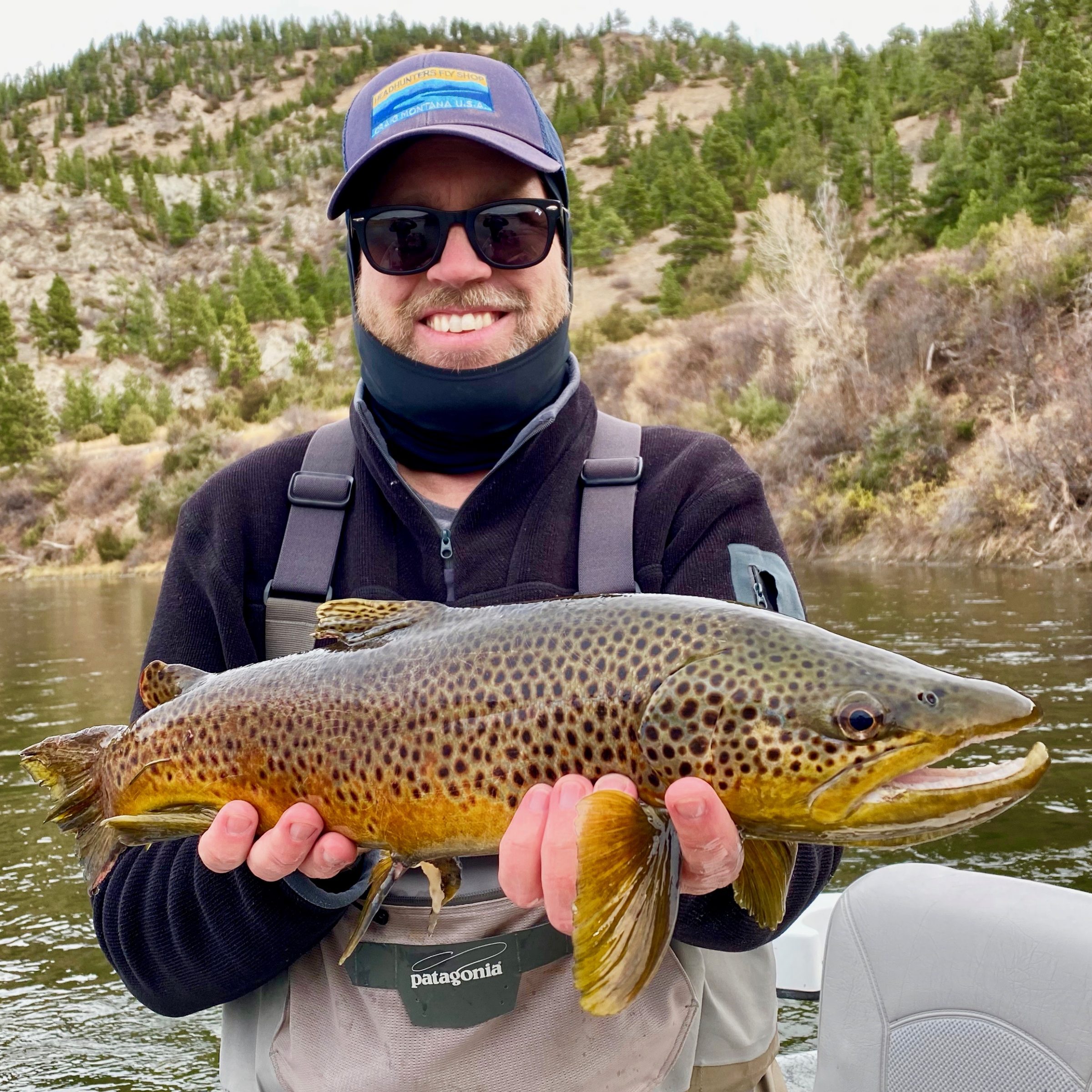
Josh got a few good ones yesterday.
Looks damn good out there to day. Dead calm, overcast, cool.
Tomorrow Sunday? Blizzard.
Shop may or may not be open. Depends on travel and whether or not Derrick wants to come on snowmobile Sunday. Could be closed early as well. Depends on Mother Nature and Mother Mo. Call first 406-235-3447
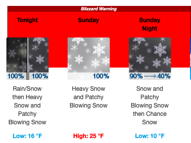 This Afternoon
Rain likely, mainly after 4pm. Cloudy, with a high near 51. North wind 8 to 11 mph. Chance of precipitation is 70%.
Tonight
Rain before 9pm, then rain and snow between 9pm and 10pm, then snow after 10pm. The snow could be heavy at times. Patchy blowing snow before 2am, then patchy blowing snow after 3am. Low around 16. North northwest wind 13 to 17 mph, with gusts as high as 26 mph. Chance of precipitation is 100%. New snow accumulation of 5 to 9 inches possible.
Sunday
Snow. The snow could be heavy at times. Patchy blowing snow. High near 25. Wind chill values as low as zero. Blustery, with a north northwest wind 22 to 26 mph, with gusts as high as 39 mph. Chance of precipitation is 100%. New snow accumulation of 9 to 13 inches possible.
Sunday Night
Snow, mainly before 11pm. Patchy blowing snow before 8pm. Low around 10. Wind chill values as low as -5. West wind 6 to 16 mph, with gusts as high as 24 mph. Chance of precipitation is 90%. New snow accumulation of 2 to 4 inches possible.
URGENT - WINTER WEATHER MESSAGE
National Weather Service Great Falls MT
321 AM MST Sat Nov 7 2020

.A major winter storm will spread heavy snow and blowing snow
south and east over much of North Central, Central, and Southwest
Montana late this afternoon through this evening. Conditions will
rapidly deteriorate this evening and overnight due to increasing
winds and falling snow. Snowfall rates from late this evening
through Sunday morning could approach 1 to 2 inches per hour at
times, mainly north of Interstate 90 to the Canadian border.
Strong northerly winds tonight through Sunday over the plains
will cause white-out conditions. Significant drifting of snow
could also make some roads impassable.

MTZ014-052>054-080000-
/O.EXT.KTFX.WS.W.0013.201108T0300Z-201109T1200Z/
Central and Southern Lewis and Clark-Jefferson-Broadwater-Meagher-
Including Helena, Flesher Pass, Lincoln, MacDonald Pass,
Rogers Pass, Montana City, Boulder, Boulder Hill, Elk Park Pass,
Homestake Pass, Whitehall, Toston, Townsend, Winston,
Martinsdale, Deep Creek Pass, and White Sulphur Springs
321 AM MST Sat Nov 7 2020

...WINTER STORM WARNING NOW IN EFFECT FROM 8 PM THIS EVENING TO
5 AM MST MONDAY...

* WHAT...Heavy snow expected. Total snow accumulations of 8 to 18
  inches. Winds gusting as high as 40 mph.

* WHERE...Meagher, Jefferson, Broadwater and Central and
  Southern Lewis and Clark.

* WHEN...From 8 PM this evening to 5 AM MST Monday.

* IMPACTS...Travel could be very difficult. Widespread blowing
  snow could significantly reduce visibility.
2 Comments.
Good swinging, Today!
5 nice fish!
The bite can definitely get hot before the shitty weather rolls in…sun to clouds, warmer to cooler, ect…. no snow to snowing. A major theme here in michigan and a game changer for smallies, trout and chrome. Even short periods of no sun, drizzle can crank up the action. Live strong and savor the great Missouri whatever the weather may be.