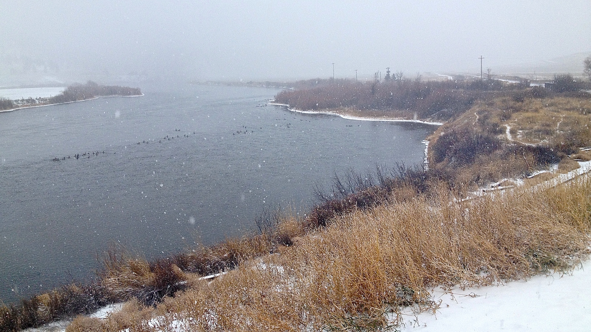
Does not look like a good day to come out to the MO.
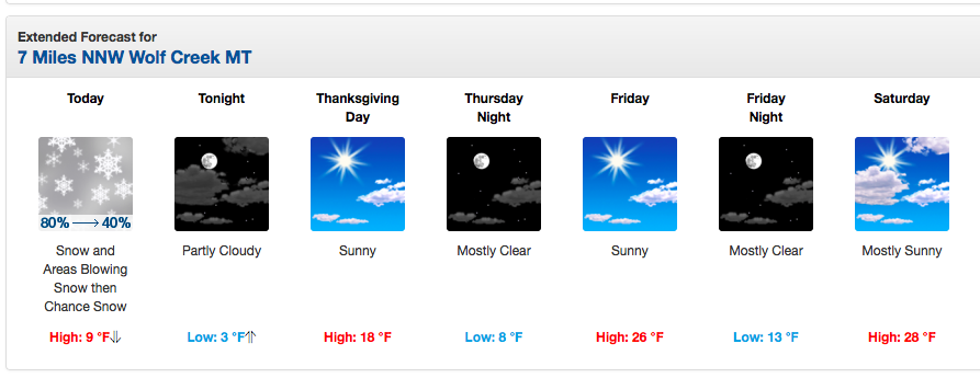
Tomorrow Thanksgiving Day met be a more conducive to trout fishing.
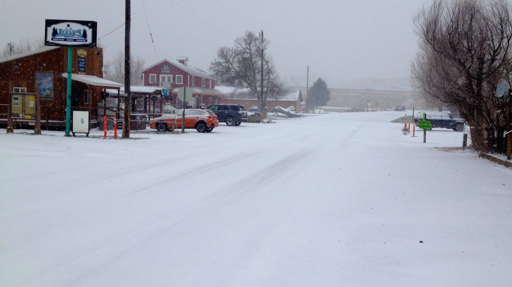
Damn cold and snowy here in Craig MT. Really too cold to fish.
Wednesday Snow likely, mainly before 11am. Cloudy, then gradually becoming mostly sunny, with a temperature falling to around 5 by 5pm. Wind chill values as low as -12. Blustery, with a north northeast wind 21 to 26 mph decreasing to 15 to 20 mph in the afternoon. Winds could gust as high as 37 mph. Chance of precipitation is 70%. New snow accumulation of around an inch possible.
One Cold Montana Holiday Week
Temps to negative 12. Too cold. Stay home for the weekend and tie a few flies. Enjoy your family, watch football, and rest.
Or we may see you this weekend. We have a few cabins open for those who want to stay a while.
Shop open Thanksgiving til about noon. Then we will drift home. You should too.
Still no word on the YETI Porch Cooler. But thanks for all of your support.
Think about your 2016 plans this weekend with you fishing buddies. Or your family. Give us a call and get yourself on the books. Sara, Ben, Braden and the rest of the gang will be available for any of your trout needs.
Swing on by and warm up your coffee. Happy Holidays.
Winter Storm Warning
URGENT – WINTER WEATHER MESSAGE
NATIONAL WEATHER SERVICE GREAT FALLS MT
NORTHERN ROCKY MOUNTAIN FRONT-EASTERN GLACIER-CASCADE-CHOUTEAU-
CENTRAL AND SOUTHERN LEWIS AND CLARK-EASTERN PONDERA-
SOUTHERN ROCKY MOUNTAIN FRONT-EASTERN TETON-JUDITH BASIN-FERGUS-
JEFFERSON-BROADWATER-MEAGHER-
INCLUDING THE FOLLOWING LOCATIONS…BROWNING…MARIAS PASS…
LOGAN PASS…CUT BANK…GREAT FALLS…KINGS HILL PASS…
BIG SANDY…FORT BENTON…FLESHER PASS…HELENA…LINCOLN…
MACDONALD PASS…ROGERS PASS…CONRAD…CHOTEAU…FAIRFIELD…
STANFORD…LEWISTOWN…LEWISTOWN DIVIDE…BOULDER…
BOULDER HILL…ELK PARK PASS…HOMESTAKE PASS…WHITEHALL…
TOWNSEND…WHITE SULPHUR SPRINGS
220 PM MST TUE NOV 24 2015
…WINTER STORM WARNING REMAINS IN EFFECT UNTIL 11 PM MST
WEDNESDAY…
* LOCATIONS…FAIRFIELD…CHOTEAU…WHITE SULPHUR SPRINGS…
STANFORD…LEWISTOWN…LEWISTOWN DIVIDE…BOULDER…BOULDER
HILL…ELK PARK PASS…HOMESTAKE PASS…WHITEHALL…BIG
SANDY… FORT BENTON…BROWNING…MARIAS PASS…LOGAN PASS…
CONRAD…CUT BANK…TOWNSEND…GREAT FALLS…KINGS HILL PASS…
FLESHER PASS… HELENA…LINCOLN…MACDONALD PASS…ROGERS
PASS.
* SNOW ACCUMULATIONS…AN ADDITIONAL 2 TO 4 INCHES OF SNOW IN
THE VALLEYS AND IN THE MOUNTAINS AN ADDITIONAL 4 TO 7 INCHES.
* TIMING…GREATEST IMPACT TO TRAVEL WILL BE LATE THIS AFTERNOON
THROUGH THIS EVENING.
* IMPACTS…DIFFICULT DRIVING CONDITIONS WITH SLIPPERY ROADS AND
REDUCED VISIBILITY IN BLOWING AND DRIFTING SNOW ALONG WITH
WIND CHILL VALUES CAPABLE OF PRODUCING FROSTBITE IN A SHORT
TIMEFRAME.
* WINDS…NORTH 15 TO 25 MPH WITH GUSTS UP TO 40 MPH.
* WEB PAGE: TO SEE A GRAPHICAL REPRESENTATION OF THIS HAZARD
PLEASE VISIT OUR WEB PAGE AND CLICK ON THE DETAILED HAZARDS
TAB.
PRECAUTIONARY/PREPAREDNESS ACTIONS…
A WINTER STORM WARNING FOR SNOW AND BLOWING SNOW MEANS SEVERE
WINTER WEATHER CONDITIONS ARE EXPECTED OR OCCURRING. SIGNIFICANT
AMOUNTS OF SNOW AND WIND ARE FORECAST THAT WILL MAKE TRAVEL
DANGEROUS. ONLY TRAVEL IN AN EMERGENCY. IF YOU MUST…KEEP AN
EXTRA FLASHLIGHT…FOOD…AND WATER IN YOUR VEHICLE IN CASE OF AN
EMERGENCY.
FOR SPECIFIC ROAD AND TRAVEL CONDITIONS IN MONTANA…DIAL 5 1 1.